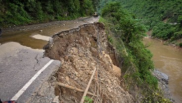
Pioneering Geotechnical Advances to Secure the Himalayan Landscape


Sources: abdn.ac.uk, gisresources.com, hull.ac.uk
Want to read more like this story?

45% of Himachal Pradesh at Risk of Landslides and Floods – What Can Be Done?
Feb, 19, 2025 | NewsA recent geospatial study has revealed that over 45% of Himachal Pradesh is highly susceptible to l...

Drones and AI Data: How Hong Kong Is Advancing Landslide Prevention
Jun, 26, 2025 | NewsWith growing attention to geotechnical resilience, new technologies are being introduced to improve...

Risk assessment of rainfall-induced landslides in urban regions
Aug, 09, 2021 | NewsA new study suggests that urban areas are more prone to rainfall-induced landslides compared to rur...

Risk assessment on natural disasters in densely populated Himalayan regions
Sep, 18, 2021 | NewsA new study focuses on the multi-hazard susceptibility of a densely populated region in the Himalay...

A Rotational Slide in Ecuador Leaves Communities Stranded
Mar, 30, 2025 | NewsOn March 30, 2025, torrential rainfall triggered a significant landslide near Chanazana in Nabón, E...

Geotechnical Engineering 2032 Boom: Trends, Challenges, and Emerging Opportunities
Mar, 03, 2025 | NewsGeotechnical engineering is at the core of modern infrastructure, ensuring the stability of buildin...

NASA maps landslides in central America caused by hurricane Eta
Nov, 10, 2020 | NewsNASA is currently mapping the landslides that were triggered during the passage of Hurricane Eta th...

Citizen scientists at NASA’s service, for the creation of the largest landslide database
May, 24, 2018 | NewsThe aim is to get a better understanding of landslides with every report made Landslides ca...
Smarter Sampling, Safer Terrain: How Machine Learning Is Redefining Landslide Risk Mapping
Apr, 10, 2025 | NewsLandslides remain one of the most devastating natural hazards in mountainous and hilly regions acro...
On This Day
August 2nd 1968
READ MORE
Related Video

Trending

Life after gINT - Rethinking geotechnical data management for a new era

Is Africa gradually splitting into two sections?

Stop Guessing, Start Designing: Introducing Support Designer in Slide2


Alert level is raised in Mexico as the Popocatépetl volcano spews ash and gas
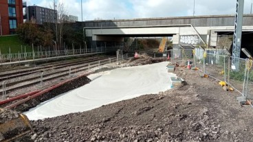
Emergency ground stabilisation protects rail works near Salford Central