News
Featured News


Aerial News
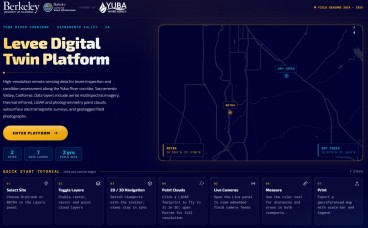
Levee Digital Twin Platform Launches for California's Yuba River Corridor
- Jun, 11, 2026
- Levees Data Management Geomatics Lidar Aerial Unmanned Aerial Systems News On Projects / Industry News On Research / Academia
- Authored by: Geoengineer.org
Researchers at UC Berkeley, funded by Yuba Water, have unveiled the Levee Digital Twin Platform — a comprehensive, interactive monitoring system built for levee inspection and condition assessment alo...
Read More
Antarctica’s subglacial world revealed in unprecedented detail
For decades, Antarctica’s ice surface has been mapped in remarkable detail, yet the terrain beneath remained one of Earth’s least understood landscapes. That gap has now narrowed significantly. Using...
Read More
Radar Eyes on Peat: Mapping Hidden Landslide Risks Across Scotland
- Apr, 04, 2025
- Slope Stability Satellite-Based Soil Mechanics Settlements Geomatics Aerial News On Projects / Industry News On Research / Academia News On Natural Disasters / Failures
- United Kingdom
- Authored by: Geoengineer.org
Peatlands are more than just soft, soggy ground. In Scotland, they cover vast, remote, and ecologically significant areas—and they are increasingly the focus of environmental restoration efforts. Bu...
Read More
Helicopters to Scan Wyoming and Colorado for Hidden Minerals
- Mar, 17, 2025
- Aerial Geomorphology Geophysics Other Geotechnical News On Projects / Industry Geology Highlights
- United States, Colorado
- Authored by: Geoengineer.org
In a groundbreaking initiative, low-level helicopter flights will begin scanning the geology of Wyoming and northern Colorado started February 2025. This airborne electromagnetic (AEM) survey, part o...
Read More
Geotechnical news recap of December 2024 now on YouTube!
- Jan, 09, 2025
- Landslides Other Geotechnical Settlements Earthquake Reconnaissance Geotechnical Earthquake Engineering Engineering Seismology Forensics Aerial Geomatics Satellite-Based Dam Engineering Foundation Design / Construction
- Authored by: Geoengineer.org
Namely, these were:
Read More
Space-Based Insights: Early Signs of Kakhovka Dam Collapse Detected
- Dec, 20, 2024
- Aerial Geomatics Satellite-Based Dam Engineering Forensics Other Geotechnical News On Research / Academia News On Natural Disasters / Failures News On Products & Services
- Ukraine
- Authored by: Geoengineer.org
The collapse of the Kakhovka Dam in Ukraine on June 6, 2023, was a catastrophic event that devastated water management systems and hydroelectric power generation. While the exact cause has been linke...
Read More
Pioneering Geotechnical Advances to Secure the Himalayan Landscape
- Nov, 29, 2024
- Geomatics Aerial Satellite-Based Lidar Landslides News On Research / Academia News On Natural Disasters / Failures
- Himalayas
- Authored by: Geoengineer.org
The Himalayan region faces a growing threat from landslides triggered by extreme precipitation, rapid population growth, and infrastructure development. Events like the catastrophic 2021 Chamoli disa...
Read More
UAVs to detect dangerous ''butterfly'' landmines
- Jul, 10, 2018
- News On Projects / Industry Aerial Unmanned Aerial Systems
- Authored by: Geoengineer.org
Low-cost unmanned aerial vehicles can collect large remotely sensed data sets to detect dangerous "butterfly" landmines in remote regions of post-conflict countries. Director of the Geophysics...
Read More
Hayward Baker River Landing Drone Video
Hayward Baker joined forces with HJ Foundations to complet a design-build project with River Landing Development in Miami, FL. Hayward Baker joined forces with HJ Foundations, and completed a desi...
Read More
3D Terrain Model Supports the City of Coatesville’s Brownfield Redevelopment Planning
CEDARVILLE Engineering Group (CEDARVILLE) was tasked to provide 3D design and conceptual planning services as part of the city of Coatesville’s “The Flats” brownfield redevelopment, a rugged, 30-acre...
Read More