
Rocscience Inc.'s Technical Workshop: Finite Element Modelling of Underground Excavations begins on Aug 26th 2026
Rocscience Inc.'s Technical Workshop: Finite Element Modelling of Underground Excavations begins on Aug 26th 2026
Create a free account and view content that fits your specific interests in geotechnical engineering Learn More
GeohazardMapping LandslideRisk DisasterResilience
45% of Himachal Pradesh at Risk of Landslides and Floods – What Can Be Done?

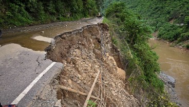
A recent geospatial study has revealed that over 45% of Himachal Pradesh is highly susceptible to landslides, floods, and avalanches. Researchers conducted hazard mapping to identify high-risk zones and develop effective disaster mitigation strategies. The findings were presented at a major climate conference, where global experts discussed the increasing risks associated with multi-hazard vulnerability in mountainous regions.

Multi-Hazard Mapping for Disaster Prevention
The study identified different hazard zones based on slope gradients and elevation levels:
- Moderate slopes (5.9° - 16.4°, up to 1,600m altitude) face high risks of both landslides and floods.
- Steeper slopes (16.8° - 41.5°) at higher elevations are prone to avalanches and landslides.
- Mountain peaks above 3,000 meters are the most vulnerable to extreme events.
Using GIS-based hazard mapping, researchers found that flood-prone regions are generally located in lower river valleys, while high-altitude areas are at greater risk of avalanches. The study emphasized how one disaster can trigger another, necessitating better risk assessment and emergency preparedness.

Recent Disasters and the Need for Action
Himachal Pradesh has suffered severe natural disasters in recent years. In July 2023, heavy rainfall caused devastating floods, landslides, and infrastructure damage, highlighting the urgent need for sustainable land-use planning and resilient infrastructure.
By utilizing advanced geospatial tools and engineering solutions, authorities can improve disaster response, develop early warning systems, and enhance risk management strategies. As climate conditions continue to evolve, proactive measures will be essential to protect communities and infrastructure in the Himalayan region.
Sources: firstpost.com, economictimes.indiatimes.com, link.springer.com
Want to read more like this story?

Risk assessment on natural disasters in densely populated Himalayan regions
Sep, 18, 2021 | NewsA new study focuses on the multi-hazard susceptibility of a densely populated region in the Himalay...
Landslides
Oct, 31, 2019 | Education

Swiss early warning system to check damage to roads due to landslides
Aug, 27, 2023 | NewsRecent instances of heavy rainfall in Rishikesh, Uttarakhand, and Kangra, Himachal Pradesh, have un...

Huge landslide levels eight buildings in Himachal Pradesh, India
Aug, 24, 2023 | NewsA massive landslide took place in the town of Anni, in the Kullu district of India’s Himachal Prade...
Smarter Sampling, Safer Terrain: How Machine Learning Is Redefining Landslide Risk Mapping
Apr, 10, 2025 | NewsLandslides remain one of the most devastating natural hazards in mountainous and hilly regions acro...
On This Day
August 23rd 1842
READ MORE
Related Video

Trending

Apr, 24, 2026 | News
Dubai approves $9.2bn fully underground gold line metro

Apr, 07, 2026 | News
How to prevent copper wire theft from light poles

Jan, 08, 2024 | News
The quicksand of Morecambe Bay

Jun, 08, 2021 | News
Model Structures and Visualize Structural Forces
Mar, 23, 2026 | News
Rapid Drawdown in Dam and Levee Design: A Hydrogeologic Perspective in Slide2

May, 21, 2026 | News
Emergency ground stabilisation protects rail works near Salford Central

May, 13, 2026 | News
