A short showcase of how we document active landslides using high-precision drone photogrammetry. On May 2, 2026, Weider360 captured a full aerial dataset of an active landslide in Pamporovo, Bulgaria (41°37′40.7″N 24°42′11.9″E), using the DJI Matrice 4E with RTK for centimeter-level accuracy. The dataset was processed in One3D.ai to generate a high-resolution 3D twin, enabling: • Accurate volumetric measurements of displaced earth • Objective risk assessment based on slope geometry • Baseline data for long-term monitoring and change detection Workflow (simplified): Flight planning & RTK-enabled data capture Overlapping aerial imagery collection (photogrammetry) Cloud processing in One3D.ai Output: 3D mesh, orthophoto, digital terrain model Equipment & Software: • Dro Show more
Related Videos


Read more about this
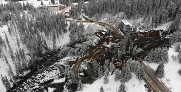
Active landslide threatens long-term connectivity in southern Bulgaria
May, 04, 2026 | NewsOne of Bulgaria’s most significant modern geotechnical failures has severed the main road between Pa...