Unveiling Ancient Settlements in Colombia with Advanced Remote Sensing
Source: tudelft.nl
Want to read more like this story?

Damage Assessment by Laser Could Focus Post-Earthquake Response
Feb, 08, 2018 | NewsAirborne lidar surveys taken before and after a powerful 2016 earthquake in Japan revealed the poten...

New Technologies for Geotechnical Infrastructure Sensing and & Monitoring 2025
Sep, 17, 2025 | EventOn November 17-20 2025, UC Berkeley Faculty and collaborators will be offering again a short course...

LiDAR technology: a new perspective in landslide risk evaluation
Apr, 10, 2014 | NewsOn the occasion of the Oso landslide, LiDAR technology comes forward, as an efficient means of revea...
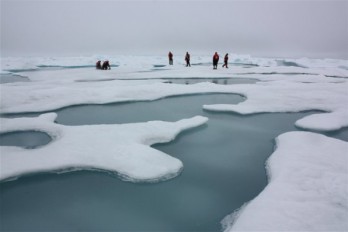
Drones in the Arctic Sea
May, 29, 2015 | NewsOne of the main jobs of geotechnical engineers is collecting and reporting data from the field. &nbs...

Drones and AI Data: How Hong Kong Is Advancing Landslide Prevention
Jun, 26, 2025 | NewsWith growing attention to geotechnical resilience, new technologies are being introduced to improve...

Washington employs LiDAR technology against landslide risk
Jan, 25, 2017 | NewsWashington's Department of Natural Resources (DNR) is making use of the best technology available to...

Advanced Techniques with 3D FEA and Satellite Remote Sensing (InSAR) Integration Case Study
Mar, 28, 2023 | NewsThis case study demonstrates how Finite Element Method (FEM) analyses, combined with InSAR remote s...

Featured Book: Underground Sensing: Monitoring and Hazard Detection for Environment and Infrastructure
Nov, 16, 2016 | NewsGeoengineer.org is pleased to announce the addition of "Monitoring and Hazard Detection for Environm...

Revolutionizing Offshore Surveys: Drones Take the Lead in Wind Farm Development
Dec, 16, 2024 | NewsThe future of offshore wind farm surveys is here, with drones set to play a pivotal role in mapping...
On This Day
June 23rd 2001
READ MORE
Related Video

Trending

New crustal stress map of North America

Using Terzaghi’s Equation in Foundation Design

Parameters Variation: Model Customization and Sensitivity Analyses

UK geothermal projects expand from Cornwall power to Birmingham heating

Stop Guessing, Start Designing: Introducing Support Designer in Slide2
Development program prepares new engineers for success